Gloucestershire County Council consulted on the Longlevens section of their B4063 Gloucester to Cheltenham cycleway proposals from Elmbridge Court to Oxstalls Lane in autumn 2022.
We’ve submitted the following detailed technical response, and also proposed an alternative solution we believe delivers a higher quality cycleway. If you’re just after the spoiler, click here to jump to what we suggested as an improved solution.
If you’d like to learn more about the standards and expertise we bring to our technical reviews, click here.
Our response to the B4063 Gloucester to Cheltenham Cycleway (Elmbridge Court, Oxstalls Lane & Longlevens) consultation
“Dear Gloucestershire County Council,
Thank you for the invitation to comment on the latest proposals for the B4063 cycle route between Estcourt Roundabout and Elmbridge Court Roundabout.
The Cheltenham & Tewkesbury Cycling Campaign committee, along with input from members secured via our newsletter and social media accounts, have reviewed the plans. We have previously shared our concerns with you about the prioritisation of this single, 26-mile corridor route over local permeability and highest potential sections, and so focus here specifically on commentary on the route proposals.
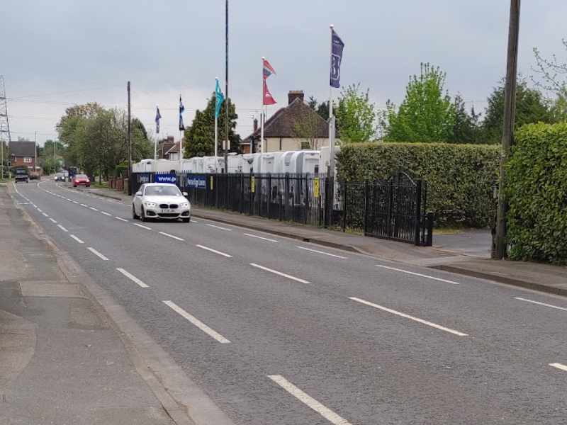
The Longlevens section is one of the most challenging sections for the corridor, running from Elmbridge Court to the Estcourt Roundabout past Oxstalls Lane through Longlevens.
It carries high volumes of motor vehicle traffic in excess of 10,000 vehicles per day, including HGVs, and is a key bus corridor, with a number of significant adjacent trip generators, particularly higher education. Commercial properties on the route also necessitate a number of pavement crossing movements, and pavement parking is a significant and consistent challenge.
Current cycle provision of narrow gutter painted cycle lanes has been demonstrated to increase risk over no provision at all, and several junctions have design features that position cyclists in dangerous conflicts with motor vehicles, particularly Old Cheltenham Road and Oxstalls Lane.
It is also a space constrained corridor, with residential properties bounding both sides, and no easy parallel route. From published traffic plans, we see no willingness to decrease the intensity of motor vehicle traffic along this section.
However, unlike more rural sections, the short distance from Elmbridge Court through Longlevens to Gloucester City Centre affords opportunity for the cycle route to enable new groups to access cycling and to promote significant modal shift, decongesting the corridor for public transport and longer distance journeys.
For this to be achieved, people must have a positive and pleasurable experience of riding the route, with it both feeling and being safer for many users.
Adverse encounters, or discomfort, will work against our shared stated aim of encouraging many more people to enjoy cycling in Gloucestershire.
Review of the proposed Elmbridge Court to Estcourt Roundabout via Oxstalls Lane scheme
Single direction section cycle way design
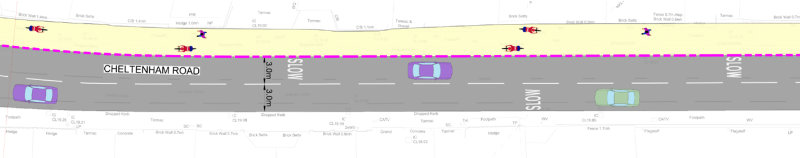
The western section of the route uses a stepped single direction cycle track, with a 75mm angled kerb both up to the pavement and into the carriageway section occupied by motor vehicles. There are three main adverse challenges with the adopted solution;
- Widths are below absolute minimum standards. LTN1/20 states the absolute minimum width should be 1900mm (1500mm + 2 x 200mm allowance for >60mm vertical features on each side) The cycleway narrows to less than 1.4m at worst, and is below compliance for significant lengths in both directions. This provides less tolerance for striking a kerb, excludes some types of adapted cycles, prevents overtaking by cyclists travelling at different speeds, and makes it impossible to use with younger children who require adjacent supervision. Should this non-compliant design be taken forwards, an enforced 20mph speed limit would at the very least reduce the impact slightly, although it cannot compensate for such narrow widths.
- Excessive proximity to heavy traffic. The narrow cycleway is unbuffered and immediately adjacent to a 3.2m motor vehicle lane, which has busy traffic in both directions. The visual separation of the cycle lane from the main carriageway is likely to mean that the majority of motor vehicle users will no longer provide a 1.5m passing distance. Given that traffic approaches from behind the cycle user who is travelling in the same direction, this will give rise to repeated close passing, and significant buffeting, particularly from larger vehicles which will often be driven even closer to the cycle lane due to the road widths.
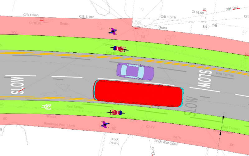
- Combined with the narrow widths, the adopted solution essentially ‘engineers in’ what would otherwise be illegal close passes, meaning a poorer experience than if the lanes were not there at all. The immediate proximity of these poor-quality cycle lane sections to the motor carriageway section also increases the risk of road aggression to cyclists choosing to stay on that main carriageway, as there will be a strong perception they should be ‘in their lane’. Combined with the kerb profiles, this risks further risky encounters between cycle users and motor vehicles.
- Kerb profiles are obstructive to lateral movement. The choice of 75mm angled kerbs not only creates a significant vertical feature with risk of slipping (down) or catching pedals (up), but also prevents the easy transition of a cyclist onto/off the main carriageway area, particularly whilst maintaining momentum. Our observation has shown that this section of the B4063 experiences regular and sustained pavement parking, and this type of kerb will make it much harder for a cycle user to go round such obstructions, to overtake a slower cycle user, or indeed to accommodate a cycle rider inadvertently travelling the wrong way. These impacts will also be disproportionately felt by those riding a cycle adapted for their disability. Based on review of practice elsewhere, this type of cycleway is better delivered either with a flat, ‘Cambridge’ or ‘Bristol’ type kerb, which provides distinction but is more forgiving to lateral cycle movement.
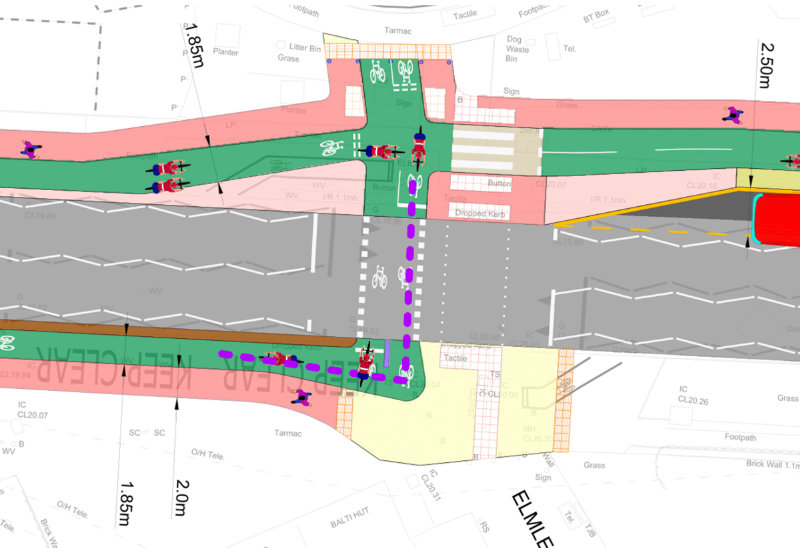
Motor Vehicle Junction design
Junctions are points of particular risk for cycle users, and are where a high number of KSI collisions occur. Features such as parallel cycle ways introduce new risks, particularly for less confident cycle users who are more likely to be in this section of the carriageway.
- We recognise a positive direction in overall approach to junction design, with the adoption of continuous materials, raised tables, and ‘Dutch’ kerbs, favouring pedestrians and cycle users. We welcome the recognition, in line with our past feedback on earlier sections, that the use of dropped kerbs for every driveway creates an uncomfortable ride experience that facilitates less controlled motor vehicle encounters.
- We support the proposed junction movement restriction of the uncontrolled filter slip from the Old Cheltenham Road, and the removal of the poorly aligned ASL and painted lane across the eastbound movement at the Oxstalls Lane junction.
- There are high risk conflict points where motorised traffic crosses the cycleway. We are particularly concerned about where the two-way cycleway crosses the entrances to the coop retail store, and the petrol station near Windermere Road. These are high traffic crossings of a bi-directional cycleway with no setback, and where a driver’s attention is often focussed away from an approaching cycle user. For example, a vehicle exiting the petrol station to head eastbound is not cued to check for approaching westbound cycle users crossing their path. Similarly, a vehicle waiting to turn into the co-op from the westbound carriageway is focussed on oncoming eastbound traffic rather than a cycle user making faster progress from behind them.
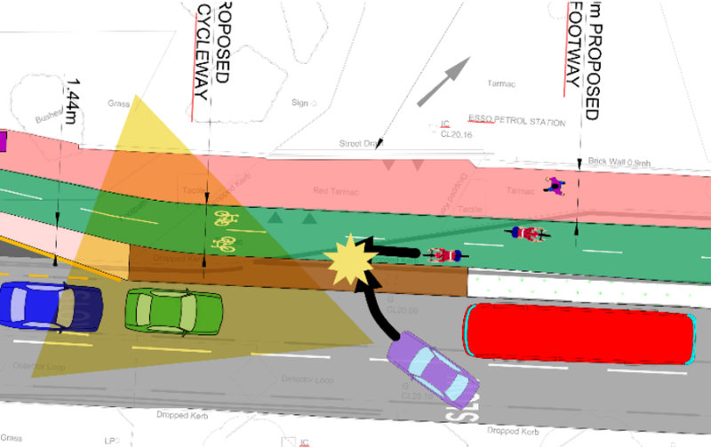
- Sight lines are restricted at junctions. The limited width of the corridor means that approaches to junctions are only set back at the last moment, meaning there is insufficient time for a cycle user to cover the range of motor vehicle approach directions. It is important that a cycle user is able to fully appreciate the range of vehicle approaches without needing to stop and lose momentum.
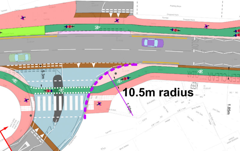
- Junction geometry remains open and focussed on faster motor vehicle movement. LTN1/20 requires a maximum corner radius of 6m for a bent-out crossing, but junctions (e.g., Elmbridge Road shows radii well beyond 10m, with the ‘Dutch’ kerbs covering several excess meters of crossing space). This allows vehicles to maintain higher speed through junctions and increases risk of collision with crossing priority cycle traffic. We believe any junctions should be significantly tightened, reducing speed and also creating more space for improved sight lines on approaches.
- Several junctions and kerbs facilitate pavement parking. The lack of a defined vehicle corridor at wider expanses of pavements near junctions will enable motor vehicles to be parked across pavement areas, restricting sightlines and mobility. Recognising the necessary minimum widths for cycles, wheelchairs and pushchairs, careful consideration is needed of planting and street furniture strategies to prevent vehicular ingress to pedestrian and cycle areas.
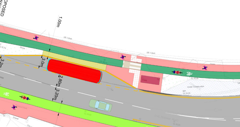
Shared path section design
The decision on this overall strategic route meant that the bottleneck near Pearman Briggs caravan dealer was inevitable, and we can see no alternative given the constrained width.
We note;
- Both the council’s own LTP (Local Transport Plan Section 3.3.8) and LTN1/20 (Section 6.5.4) identify that requiring pedestrians and cycle users to share space is unsatisfactory in urban environments, particularly in locations like this where there is also significant pedestrian movement amplified by the limited footways crossing the Horsbere Brook, and that whilst the labelled sections are above 3.0m, some sections at constraints even fall below this absolute minimum.
- In recognition that more cycle users are likely to stay on the motor vehicle carriageway through this section, we would advise provision is made for cycle users to leave and join the cycleway easily at the approaches, and that cycle symbols be installed centrally on the carriageway to reinforce the expected presence of more cycle users in this location.
- We also encourage the council to explore opportunities to provide pedestrians with better alternatives, such as a crossing to allow pedestrians to use the southern footway, and opening up a path along the Horsbere Brook easement to Kimberley Close, to create a more dedicated cycling area on the northern side.
Route coherence
Coherence reflects the overall legibility of the route, and how easy it is for riders to understand where they should be and where they are going.
- There is a complex mix of different types of cycle path, causing the route to lack coherence, particularly for occasional users. As well as creating a poor experience, this introduces additional risk where a cycle user heads the wrong way down the very narrow, kerb bounded, single-direction cycle tracks. Particularly heading westbound, a cycle user must recognise the very abrupt left turn across to the Southbound side at Windermere Road, which could easily be mistaken for a north/south crossing route. The different mix of types of tracks also make positioning and flow much harder to achieve.
- There are challenges with the ‘turn in two’ arrangement into Nine Elms Road. As well as varying from the LTN 1/20 diagram, this is a new and unique type of movement for cycle users in Gloucestershire. It is likely to be disorientating, and risks cycle users finding themselves unexpectedly in a flow of traffic, or taking the wrong route. Particularly given the design intention of the route to be accessible to less confident cycle users, this appears to be the wrong choice. There is sufficient space at this junction with only limited road space reallocation to create an all ways set of protected movements, and this would be preferable.
Cycle crossing design
The route appropriately uses a number of signalised crossing movements when moving the cycleway across the main carriageway. However, these are particular points that impact on coherence, and the overall capacity and utility of the route for the mass transit of cycle users.
- The majority of the cycle crossings, for example at Windermere Road and Oxstalls Lane appear to have not been designed with cycle geometry in mind. In particular, there are sharp turns up to 270 degrees, and limited waiting space. For example, cycles heading north to south at Windermere Road will block West to East movements, and similarly, cycles waiting to make the popular south to north movement into Oxstalls Lane will block cycle traffic heading into Gloucester.
- With appropriate highway reallocation, and crossing repositioning, it is possible to create additional width to allow cycles to bypass queuing cyclists. Given its importance, the transition to the southbound carriageway at Windermere Road is particularly tight, and we believe at the very least, a diagonal crossing should be used to facilitate gentler lines, and to at least create some coherence.
- There appears to be no provision for a cyclist leaving Oxstalls Lane southbound to be able to access the cycle route heading west, or to cross into Grafton Road. This risks cycle users travelling the ‘wrong way’ along single direction cycle tracks, at a narrowed section.
Bus stop design
One of the challenges where overall corridor width is limited is that pedestrians and cycle users are forced into narrower spaces rather than impede motor vehicle flow. Bus stops have also been particular points of controversy in previous schemes, and have specific equality impacts that need to be considered.
- There is pedestrian/cycle conflict at several of the bus stops within this scheme, particularly created by the decision to retain several bus laybys, a measure largely focussed on maintaining private motor vehicle flow. The design of some bus bypasses does not recognise pedestrian desire lines, nor the visual restrictions that street furniture will introduce. We believe that bus stops should be retained on road to provide more space for more comfortable passing.
Unmarked elements
The plans do not show a range of important features, such as sign poles and new cabinets.
- In our previous contributions to other elements of the Gloucester to Cheltenham cycleway, we have consistently found that unmarked street furniture, such as signage, electrical boxes, significantly impair the quality of the route. We also note that stated widths are often compromised by the width of the physical materials used to bound them. This is evident in the existing provision near the Elmbridge Court roundabout, where multiple obstacles are present directly in the cycleway, and in mistakes made in siting signage along the West Cheltenham Transport Improvement Scheme. We are obviously unable to comment on unmarked items, but strongly request their presence is carefully considered, and the impact of vertical features (as described in LTN 1/20 Table 5-3) is acknowledged when assessing compliance.
- Again, from our experience of other recent Gloucestershire County Council highway schemes, the locations of push buttons for cycle crossings is important for accessibility, and these have generally been poorly implemented to date. We encourage the council to specifically engage with cycle users on the positioning, heights and orientation of crossing buttons, and to consider adopting a general principle of automatically triggered approach sensors on the main desire lines.
- The timing of lights will also affect the desirability of the route, and again, past schemes such as the Telstar Way crossing have shown that extended waits encourage cyclists to attempt to make progress through moving traffic flows, or to remain on the faster carriageway route.
Estcourt Roundabout
- Whilst noting the roundabout forms part of a separate scheme, we are concerned that the narrow approach and departure lanes form a poor basis for resolving this junction, and that ultimately given the very high risk at this location, the value of this Longlevens section (which is unlikely to be complete until 2024), is massively restricted until the roundabout risk is also addressed. We have a particular concern that by constructing this section in isolation of the roundabout, less confident cycle users will be drawn into attempting the roundabout, increasing the likelihood of significant harm until the route is continuous.
- Irrespective of route taken, in enabling all direction movements, Estcourt Roundabout requires substantial revision. At the volumes of traffic for this location, it cannot be safely designed for cyclists as a roundabout, and we urge the council to progress a change for this being a signallised crossroads junction.
- Given Estcourt Roundabout is not included within this phase of the works, we strongly encourage the council review additional enabling measures on the parallel routes, particularly through removal of the barriers that prevent easy cycle traffic travelling via the Oxstalls Campus to rejoin the Estcourt Road having crossed Wotton Brook.
Our C&TCC recommendation for an alternative scheme
Our above critique identifies a number of issues that are below minimum UK standards, and which pose safety risks. Whilst we have recommended improvements wherever possible, we believe that these are insufficient to deliver a route of significantly enhanced value to current and future cycle users.
We have carefully considered a range of alternative solutions that might be possible within the constraints, which we believe enhance the desirability, safety and deliverability of the project, and which are more likely to increase ridership.
We propose an alternate configuration to Gloucestershire County Council which we believe has greater coherence, safety, and desirability, and which can more quickly deliver the continuity into Gloucester that the council is attempting to achieve.
We suggest that instead of continuing the two-way cycleway past the supermarket and petrol station, and then splitting into insufficient single width tracks, that the two-way cycleway transitions through a single stage diagonal crossing at Old Cheltenham Road to the southern side, where it continues as a two way cycleway until Grafton Road. We then suggest that the route is taken via Kenilworth Avenue, and across a single stage traffic light-controlled crossing of Estcourt Road, before merging back into the London Road facilities through a reconfiguration of the junction at the top of the hill.
The safety of this approach can be further enhanced by a diagonal filter of the Kenilworth Avenue/Grafton Road junction, and closure of the Elmbridge Road/B4063 junction, which delivers additional benefits towards a Low Traffic Neighbourhood south of the B4063, a principle the council has recently stated its support for.
An indicative plan is shown here, and from our measurements, a route compliant with LTN 1/20 can be achieved along the full length, unlike the proposals presented in the consultation.
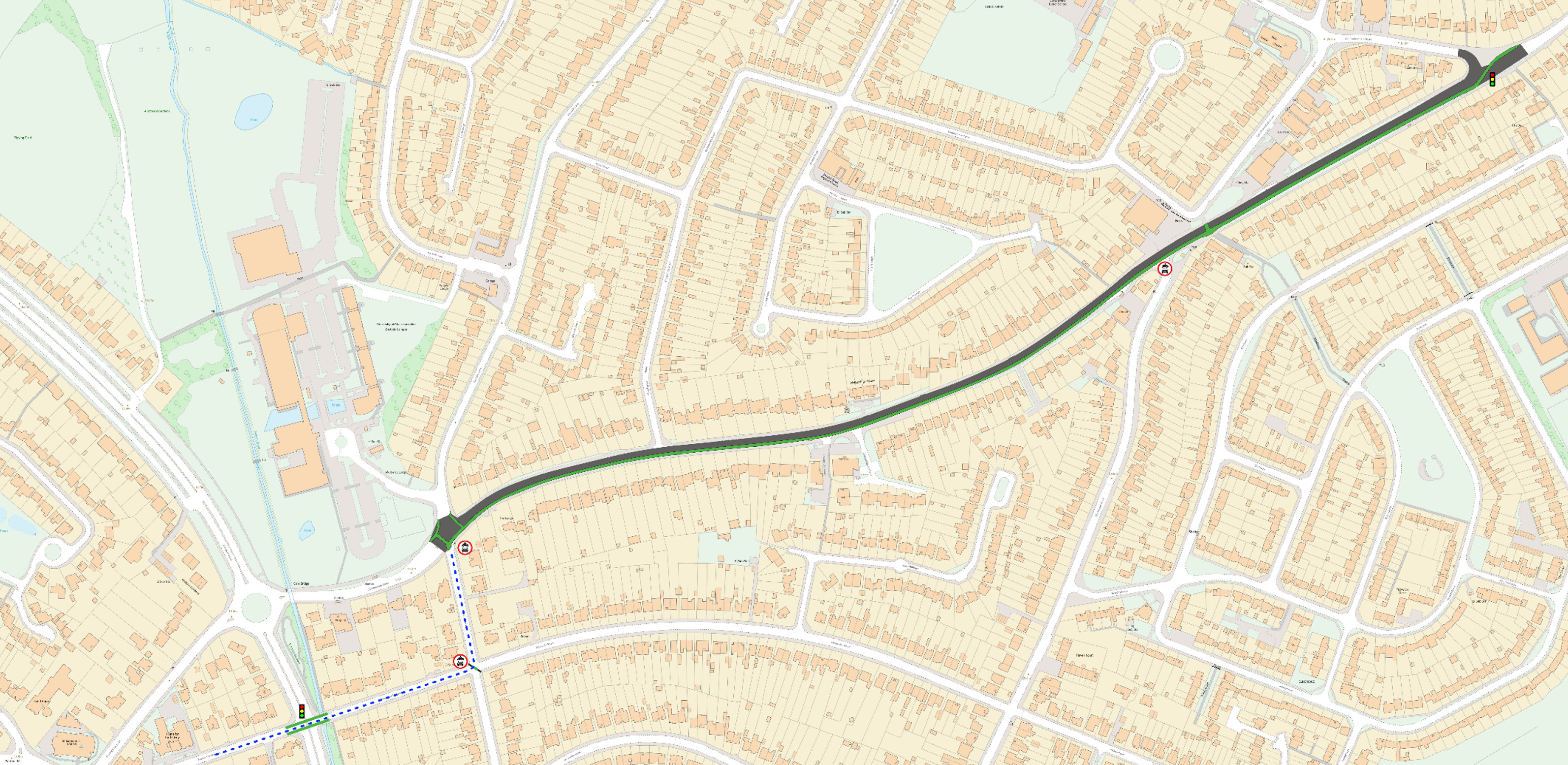
Alt text: A diagonal two-way cycle route transition at Old Cheltenham Road moves a generally 3.0m cycleway onto the southern side of the carriageway, and is continuous until Grafton Lane, supported by a modal filter at Elmbridge Road, a parallel crossing at Windermere Road, and an all-ways movement junction at Oxstalls Lane. The route then passes through the existing modal filter onto Grafton Road, through a new diagonal (NE/SW movements) filter with Kenilworth Avenue, before crossing the Estcourt Road at a signalised crossing. From here, the route can be easily meshed into the existing London Road facilities at the western end of Kenilworth Avenue (west) through junction reconfiguration.
What are the advantages of the C&TCC alternative Elmbridge Court to Estcourt Roundabout scheme?
We judge the advantages of a two way cycle track on the south side of B4063 to be;
- Provides generally greater buffer from passing traffic, and avoids need for any section of cycleway to be below LTN 1/20 standard, whilst protecting 6.0-6.2m motor vehicle carriageway width.
- Removes major conflict points outside petrol station and coop, and with point closure of Elmbridge Road junction has no crossing motor vehicle traffic lanes.
- Greater coherence and continuity, without mix of types of track along single section.
- Affords greater choice, particularly to cycle users who stay on street for shared path section
- Reduces risk of road violence against cycle users remaining on road, as discrete rather than alongside motor traffic
- Allows eastbound cyclists good visibility of oncoming larger vehicles with choice to anticipate and deflect away from the kerb edge given the 3m cycleway width.
- Creates a simpler, and achievable all-ways movement junction at Oxstalls Lane.
- Overtaking by cycle users is possible, creating greater comfort for cyclists travelling at different speeds, and parents and carers can ride alongside children.
- Halves the number of conflicts with bus stops, allowing some bus laybys to be retained.
- Contributes to reduced motor vehicle traffic cutting through south of route, enhancing accessibility of the route to local communities in this area.
- Simplifies infrastructure required to cross Estcourt Road.
- Protects northbound side of B4063 as a pleasant and separate pedestrian route.
- Is immediately usable upon completion, rather than awaiting completion of the later Estcourt Roundabout phase of works.
Whilst the cycling campaign can see that extensive and detailed design work has been undertaken on the consultation proposal, we believe that the low quality of the overall ride experience will not create the conditions for a significant number of additional people to feel confident and enjoy cycling this route. We also note specific safety concerns that the proposals may expose both confident and new riders to, and that these are difficult to mitigate within the existing scheme.
Whilst we were not approached at all during the early design phase for this section, we would still welcome the opportunity to work with Gloucestershire County Council to explore our alternative proposal with you as a potential way to provide an enhanced and better value for money solution along this section.
Submitted by the Chair on behalf of the C&TCC Committee“