Gloucestershire county council consulted on the next section of the Gloucestershire Cycling Spine in June 2023. This section connects the racecourse roundabout to the end of the Honeybourne Line as it meets Tommy Taylor’s Lane.
Whilst we have been critical about the overall strategy of focussing all money onto a single 26-mile route, this route to connect Cheltenham to Bishop’s Cleeve has been a wish list priority for the campaign for many years. We are glad to see plans finally be developed for this section which has a high potential for modal shift and additional active travel journeys.
We structured our response to the consultation into two parts; a detailed review of the route proposals, and then a wider comment on how the route will contibute to the overall network density.
A435 Gloucestershire Cycle Spine – detailed design feedback
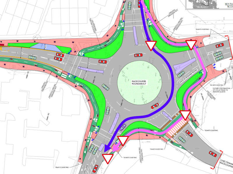
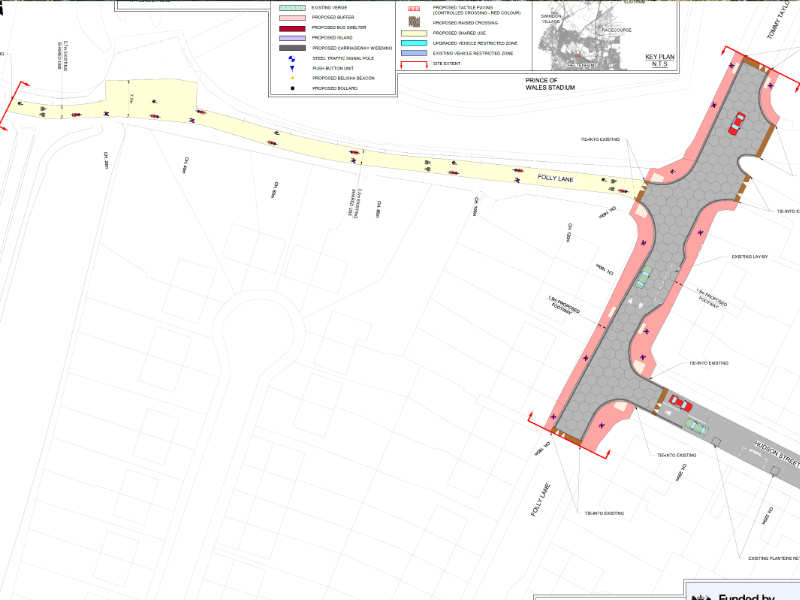
Racecourse roundabout
The large, double gyratory roundabout, is in our opinion, the greatest uncontrolled risk along the route section, presenting significant challenges for the cycleway. We have previously highlighted to you that we believe a signalised junction with parallel cycle facilities would be more suitable both for safety and desirability, rather than attempts to reverse engineer a fast and busy roundabout.
Our greatest concern is that the geometry of all exits of the roundabout are still built for speed of motor vehicles. This is compounded by the double lane arrangement on some arms which restricts sight lines and increases task loading on drivers at this location. We believe it is likely that some vehicles exiting the roundabout will fail to expect, notice or observe the discrete crossing lights and that they will have insufficient stopping distance to avoid a crossing user.
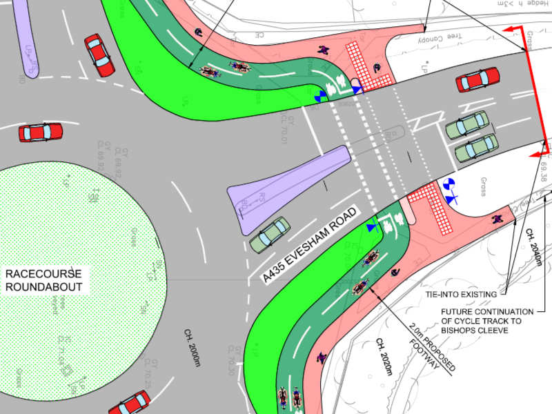
Given the increase in pedestrian and cycle use, and the gateway to residential areas, we strongly recommend the tightening of radii and approaches such that they require lower speeds, designing down the risk of collisions if traffic signals are not observed. We also believe all exits should be single lane only, so that drivers are focussed ahead rather than looking in mirrors or to the side as they merge on exiting the roundabout.
There must also be recognition that some cyclists will continue to use the carriageway through the roundabout because it will be the quickest route and their safety should be accommodated. Particularly when making east/west movements, cycle users face a choice between three successive stop points, or remaining on the carriageway where they are liable to increased driver hostility. To be at least partly effective, signals at this location need to be sensor driven, and immediately responsive if not activated within the previous 30 seconds.
It should also be recognised that, whatever the design of the cycle route north of the roundabout, use of the carriageway by northbound cyclists will remain common due to the favourable downhill gradient and the ability to travel quickly, and so on carriageway safety through the roundabout must also be considered, and indicating that cyclists should also be welcomed on the carriageway, for example through centrally placed cycle symbols, is important.
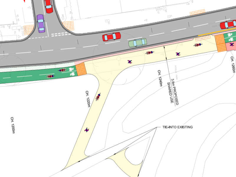
We recommend further consideration of how the crossing of the racecourse arm will function during major events. Whilst the racecourse arm is built as a low traffic crossing, there will be periods when it both needs to keep cycle users safe whilst handling higher volumes of non-local traffic, and cope with higher numbers of cycle users as residents and racegoers attempt to avoid the additional motor vehicle congestion events create. We would suggest a narrowing of the junction throat width to a single vehicle, and planning for temporary signalling if required.
More generally, it needs to be recognised that during race week, specific measures will need to be considered for the cycleway (as are currently undertaken for motor vehicle traffic) to ensure it remains desirable and usable, both because of excess pedestrian volumes and the higher likelihood of illegal parking.
A435 Evesham Road
We support the built priority across the residential access points.
The offset pedestrian crossing point to the south of Cleevemont road is unlikely to be used as designed. Given the low traffic use onto Cleevemont, we would suggest a narrowing of the junction throat and kerb radius, and built priority through a dutch kerb, to allow this to be a direct route.
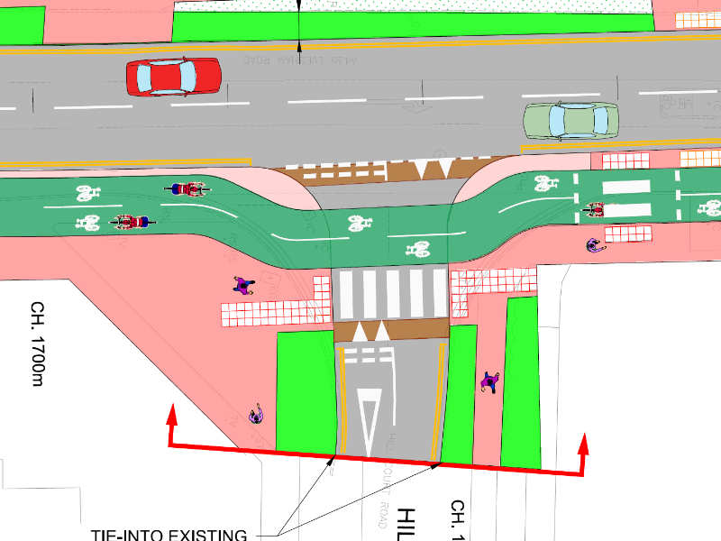
The crossing at Hill Court Road appears to be inadequately set back, clearly constricted by the boundary on its northwest corner. We suggest changing this to an exit only, making Hill Court Road one way, eliminating the risk and allowing the cycleway to remain adjacent to the carriageway.
Cycle facilities at West Approach Drive appear compliant. However, given the likelihood of displacement of parking from Evesham road onto Albermarle Drive, we would suggest built priority for the footway crossing and a Dutch kerbway here to maintain pedestrian comfort.
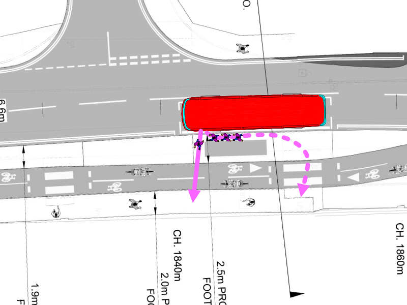
Bus stops adjacent to cycleways remain controversial if not implemented well. Here, we note the point at which people will dismount a bus has not been intuitively aligned to the painted crossing (which will be behind them, and hidden by boarding passengers). We suggest a review of this layout and the stopping point so that the crossing is used, with good sight lines for cyclists, particularly those approaching from the north.
Experience from the A40 has shown that, even with adjacent pavement facility, pedestrians often choose to walk in the cycle way, and the removal of the pavement completely within this section of the proposals creates specific challenges.
Materials and signage here will be crucial to ensure that this is clearly identifiable as a cycle track; This might include having this section at carriageway level, with gaps between planting sections showing its continuity. Repeating cycle only signs should also be used, with a continuous surface colouring, along with a separate sign indicating the pedestrian route.
The approach from the shared path section along the A435 north of the toilets presents similar challenge. Without very careful implementation, there is a significant likelihood of pedestrians remaining on the cycleway heading south. Given the adequate widths throughout, we would suggest instead that the cycleway is made continuous here, again at carriageway level, with an adjacent pedestrian footway. This also provides opportunity for the cycleway to formally stop at the pedestrian crossing alongside motor vehicle traffic, simplifying movements and giving appropriate priority to pedestrians. It also removes transitions from shared path to cycle track, simplifying the street environment and reducing the number of tactile strips.
Similarly, at the southern end of this section, we suggest that a diagonal path is created for pedestrians through the park to connect the pedestrian crossing at Central Cross drive with the footpath running north from the café, respecting the desire line for those on foot.
Central Cross Drive
The use of two bollards on the approach to the junction appears to create gaps below current standards. A single central bollard is the most that should be required. As drawn, they obstruct cycle flows in both directions.
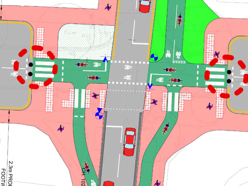
There is great opportunity here to use a sensor-controlled light with advance detection on approach to provide a continuous riding experience. This should be the standard on all cycle crossings.
There is a missing give way on the cycle slip exiting off the A435 northbound meeting the east/west crossing route.
West Drive
With the proximity to Dunalley Primary School, careful consideration needs to be given to this section, particularly as the closure of Central Cross Road will create a tempting cul-de-sac and turning point for school drop off traffic, at the same time as the route is likely to be busy with cycle users.
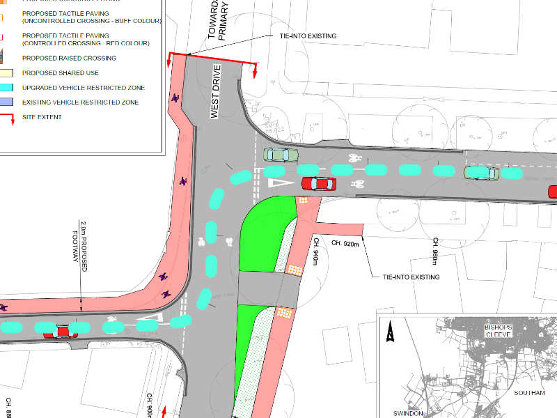
We suggest a ‘no access to motor vehicles except for access’ signage on this section.
We also propose a change of priority to prioritise flow from Wellesley drive onto West Drive northbound, requiring vehicles approaching from the south to give way. This provides better priority for through cycle traffic, and helps slow motor vehicles through this section.
We also suggest clear no parking lines on both sides of the road throughout these two junctions. Whilst parking at junctions should already be prohibited, experience elsewhere has shown double yellow lines are required if this is to be observed during peak periods.
Marle Hill Road
With the large central tree, bollard use here appears excessive, and clearances should be reviewed to ensure accessibility compliance. It may be possible to remove the bollards completely, or at least ensure 1.5m gaps.
Local cycle users also report near misses along this section due to the widths and vehicle movements, and some additional sections of controlled parking or change in carriageway width would benefit safety.
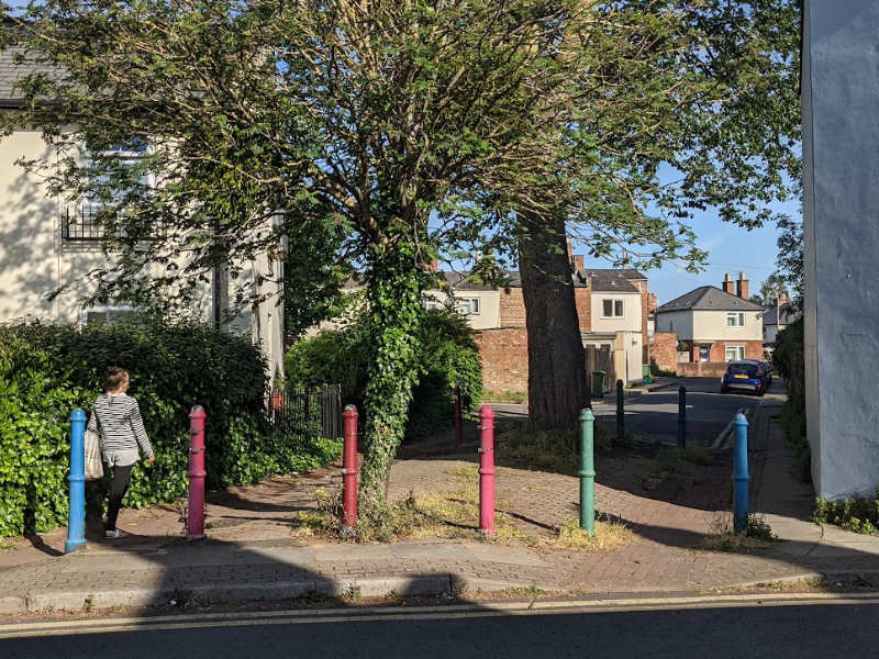
Hudson Street
This existing low traffic area shows the opportunities that can be realised by controlling motor traffic in residential areas.
Whilst generally satisfactory, the negotiation of the interface with St Paul’s Walk is poor, requiring access to a narrow, shared space section via sharp turns, particularly on the approach from the east. We would recommend additional parking measures and appropriate deterrent infrastructure to prevent vehicles blocking these approaches, and use of a small section of the adjacent green area to create a wider and more accessible passage. Widths either side of the existing bollards are also narrow and offsetting the bollard to one side could make access easier whilst still preventing motor vehicle flow.
Folly Lane/Tommy Taylor’s Lane
The short main carriageway section of Folly Lane is clearly a challenge, and we acknowledge some compromise is likely to be required here until bolder moves can be made.
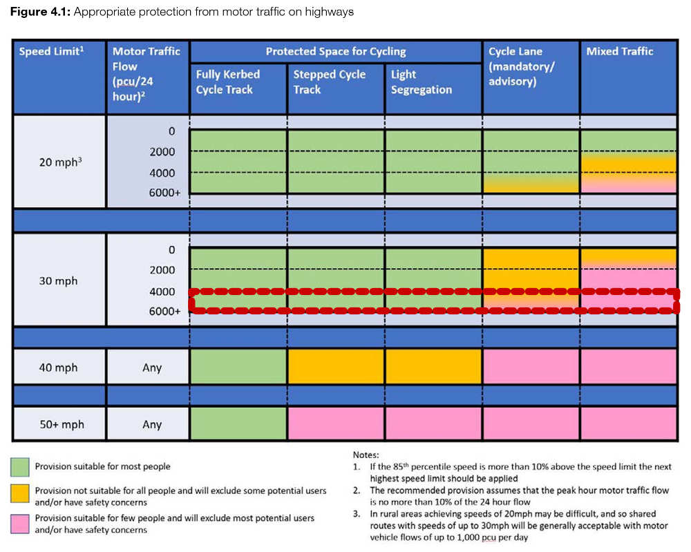
From recent Department for Transport measurements, traffic volumes on this section are too high for any mixed traffic solution to be comfortable for all riders and to meet the expectations of LTN 1/20 which an ATE funded scheme should aspire to. There is also a particular conflict of cycle users with vehicles exiting left from the leisure centre who will only be looking to the right for oncoming vehicles driving towards Cheltenham.
We propose that additional measures need to be taken to reduce the number of vehicles using this stretch, such as a northbound bus gate north of the leisure centre, diverting significant traffic to the higher capacity parallel roads and supported a general improvement in the local street environment. We also propose additional speed cushions along the approaches to this junction on both Folly Lane and Tommy Taylor’s lane to slow traffic before it reaches the point of maximum risk.
We suggest the council takes the opportunity to build pavement priority across the leisure centre entrance and exit (as it is doing along the Longlevens section), which would also help slow vehicles approaching the road and convey they are entering an active travel focussed area.
No road markings are shown for this area. It is unclear if the council is intending this be a shared space, but the current traffic volumes mean this is unlikely to be successful and we recommend that junction marking in the form of appropriate give ways are required.
Finally, a ramp is shown onto the raised table from the cycle only west approach. This could be removed to make a more comfortable riding experience as cycles do not need to be aggressively slowed as motor vehicle traffic.
Folly Lane
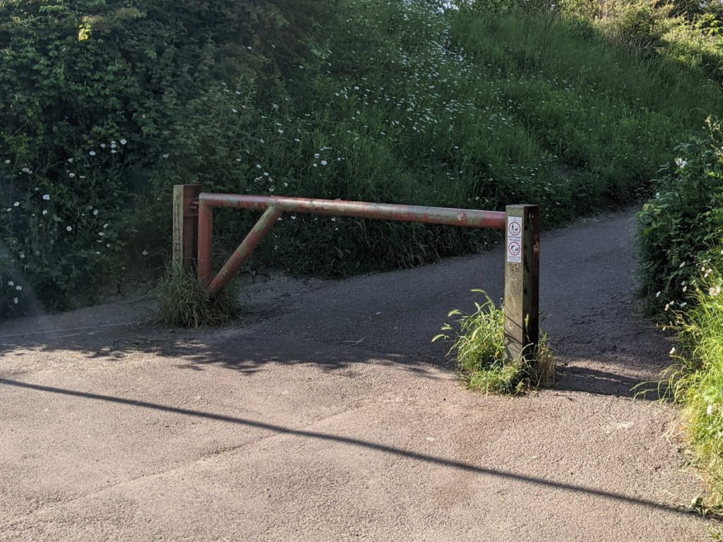
It is unclear if any works are planned on this section, but the existing motor vehicle barrier presents a significant bottleneck and conflict point on the shared path. Our recommendation is remove and replace with 1.5m spaced lockable bollards which can be removed when access is required. The ideal configuration would be a single central bollard, and then further bollards beyond the path boundary as required.
We note that whilst drawn as a shared path, there are currently vehicle movements into the rear of one property. There needs to be clarity on the nature of this section, and where motor vehicle movements are permitted, with appropriate design to secure its use.
The current indication shows cycle symbols being painted. As a shared path, this is incorrect. The appropriate alternative symbol should be used.
GCC must also work with CBC on the exit from Folly Lane onto the Honeybourne line southbound, where a further substantial barrier creates an even tighter pinch point on the uphill section to join the main Honeybourne line. This is a complex T junction with limited sighting lines at present, and a collaboration between all interested parties to design an appropriate solution is likely to be required.
Wider network comments
Opportunities for local route connections
We are pleased to see an important link being finally progressed. To be effective, the council will need to accept some reduced motor vehicle flow capacity particularly at the racecourse Roundabout, which will represent a reversal of efforts in recent years to maximise private motor vehicle flow.
Whilst the work to improve the environment for cycling on the Evesham Road is to be welcomed as part of the longer distance route to Bishops Cleeve, the proposals do not address key desire lines within the area, nor address some of the existing significant barriers.
The proposals may help east west cycle traffic on the St Peters /St Pauls to Whaddon /Prestbury axis, but do not provide the optimal route for journeys from Bishops Cleeve via the Honeybourne Line.
The back-streets at present provide a reasonable network for journeys in this part of town, particularly if supported by additional modal filtering. The track on Evesham Road is an improvement but does not, as it stands, address barriers in the direction of the town centre. It is important for there to be rapid delivery of an onwards route into Cheltenham town centre, particularly recognising the hostility of the one-way system around Winchcombe Street. Without this, the proposals will have significantly lower utility, and even interim junction measures would be welcomed. We are happy to work with the council on these, highlighting as priorities;
- Evesham Road towards town presents a significant barrier. It is disappointing that the junction with Albermarle Gate/West approach drive is poorly designed when there is a key requirement for journeys east west, for school traffic in particular. Albemarle Gate is also a quick direct route between Evesham Road and Honeybourne Line.
- Routes through Pittville Park should be explored for links between Evesham Road and the Honeybourne Line to give necessary network density. An additional short section of path and crossing along the desire line from Prince Regent’s Avenue into the path on the west section of Pittville Park is a high priority.
- Being more ambitious, Tommy Taylors Lane is a barrier that has not been really addressed with the proposals. The original plan dating back some years was to cross from the Honeybourne line branch to a track along the boundary of the Leisure Centre Car park and into the park. This would avoid the dog leg into Hudson Street, and provide better east/west connectivity.
- An additional parallel crossing of the Evesham Road north of West drive to connect the two sides of Pittville Park, which are currently separated for cycle users by the narrow tunnel.
- There is a desire line across the open space to the west of Tommy Taylors Lane that could be developed as one of the links with the Evesham Road Route to the Honeybourne Line. The incoherent and narrow path through to Wymans Brook as far as Windyridge Road also needs development, recognising the desire line to Pittville School across the old railway.
Without these issues being addressed, many local communities will be unable to derive the benefits of the core strategic route, and given the relative costs compared to the whole scheme, and the challenge of securing additional funding outside of strategic projects, we would ask they could be considered for inclusion.
Lessons from other sections of the Gloucestershire cycling spine
We would also like to provide some commentary informed by feedback we are receiving on other sections of the cycle spine that have already been constructed;
- The commonest criticism of the Gloucester route as so far implemented concerns the perceived unsatisfactory quality of the surface. Machine laid tarmac should be used to the same specification as for roads, without additional painted surfaces overlaid. Where colour is required, this should be incorporated into the tarmac, and not applied as a slippier oversurface.
- Another criticism is that the cycle track is placed at footway level when adjacent to motor vehicle traffic, and not at carriageway level. This creates a stressful environment when riding adjacent to roads (with the possibility of an error causing a cyclist to ride into the road), and also results in the discomfort caused by changes in level at road and access crossings. This route should be implemented consistently at carriageway level wherever possible.
- There should be frequent opportunities to transfer between cycle track and carriageway, both for access and to suit riding preference.
- We are observing significant problems with cleansing and the accumulation of debris thrown from the road, and no snow or ice clearance in winter. If the council intends to construct separated lanes that do not have the benefit of street clearance, it needs to specify and fund an effective cleansing and maintenance routine from the outset.