The committee chair and a local resident member had an opportunity to meet with the project team and lead contractor for the Phase 3 and 4 West Cheltenham Transport Improvement Scheme (WCTIS) works to discuss the recently released final plans. The plans are available on the GCC website, but will not be subject to further formal public consultation; we therefore appreciated the chance to have a detailed walkthrough along the route.
This is not a formal campaign reply that has been considered by full committee, but a reflection of notes from the visiting team, supported by previous member and committee input. The feedback we’ve provided is within the very specific context of the scheme being advanced, and therefore the scope of change is limited by the planning and political decisions already made;
- No changes can be made to road widths
- No changes can be made to speed limits
- Boundaries of the scheme are fixed
- No substantial vegetation removal is possible
- Minimal changes are possible to junction alignments
The recommendations we’ve made have to sit within these constraints. This is important to highlight as some areas would not have been our preferred solution, but we have offered advice where we think the drawn proposals would be unsafe and could potentially increase risk to street users, or result in an unsatisfactory outcome.
West of Benhall Roundabout
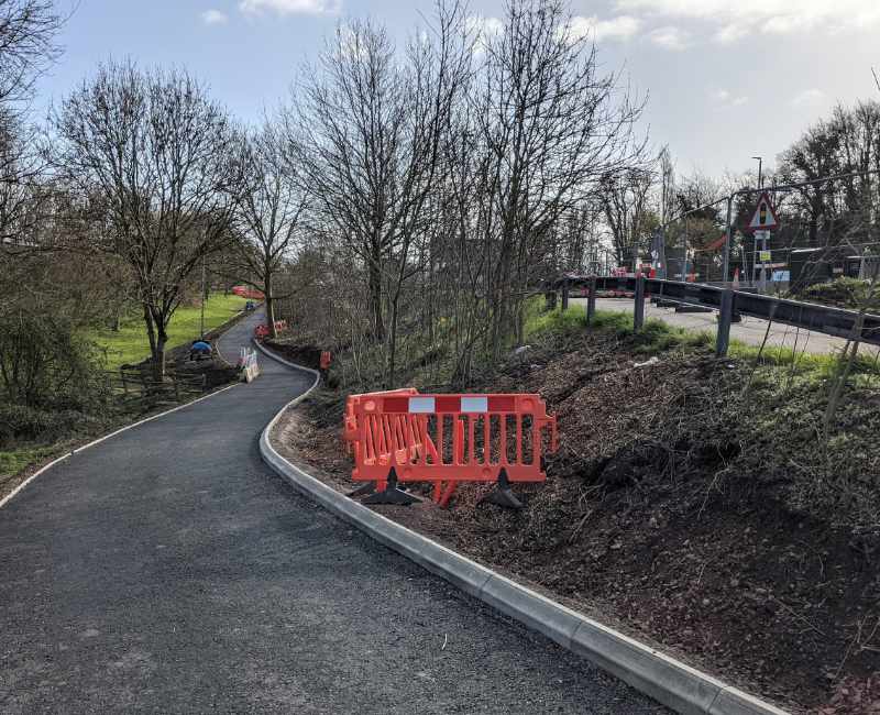
The majority of construction is already complete on the section west of Benhall. A shared-use path passes the A40 frontage of GCHQ, before crossing Telstar Way as a single phase crossing (which we are encouraged to see has been added having been highlighted in our original response). The subway sections are being completed, and show kerb separated cycle and pedestrian paths. Corners are disappointingly sharp on entrance to the subway (risking a wheel being clipped), but the cycleway is placed on the outside, providing visibility.
These kerbs are important to note. As the council moves away from paint for segregation, cycle paths must be of sufficient width as cycle users cannot easily deviate into the footpath area to either overtake a slower cyclist, or for two wider cycles to pass comfortably. LTN 1/20, the design standard, describes this as being 3.0m in most circumstances.
Benhall Roundabout
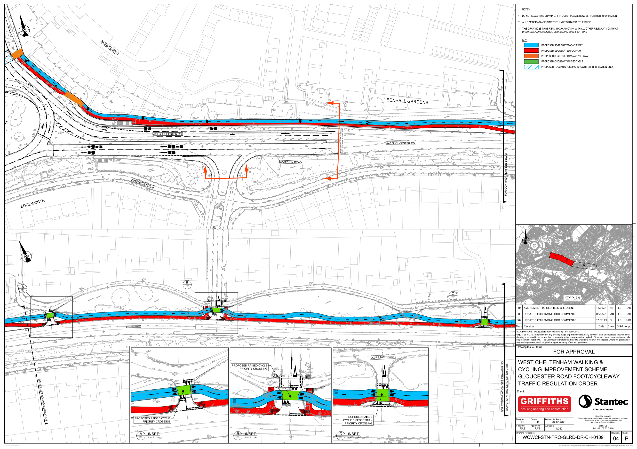
The Benhall roundabout crossings are already built. We’ve highlighted the opportunity of upgrading the crossing to the west of the roundabout to a toucan to provide an alternative for those unhappy to use the subway, but the tight angles of the built scheme make this difficult. The crossing on the exit arm towards PE Way is a welcome addition, although there is some significant deviation for those who have approached from GCHQ, and we anticipate many riders may choose to stay on Miserden Road when heading into Cheltenham.
Our one request on this section is consideration of a path connecting the A40 crossing opposite Telstar Way to Miserden Road, avoiding the very narrow swept corner to access the crossing.
On the eastern side of the crossings, we’ve advised that having a short section of segregation to the subway introduces need for two ‘rumble strip’ tactiles, and actually makes exiting the crossing more difficult on the desire line for cycle users. Given there is insufficient width to create continuous segregation within the scheme’s scope, we believe having a widened shared space avoids the stop/starting of segregation and gives cycle users more width to exit the crossing. (The ideal here would have been to reconfigure the subway ramp and use adjacent land to provide continuous 3m provision up to the crossing.)
The cycleway then becomes a 3m width segregated path, of comfortable and direct quality. We’ve flagged the need for good vegetation management on this section, both to protect width, but also to ensure pedestrians crossing from the housing to the footpath can see approaching cycle users.
Side Road Treatments
Granley Gardens
Each of the side roads is handled with a raised table crossing, set back as far as junction geometry allows, with cycle priority at Granley Gardens. We’ve identified the opportunity to reinforce cycle priority through a distinctive surface treatment and cycle symbols being placed on the crossing not the approaches.
Tennyson Road
Our greatest concern was for the approach at Tennyson Road. As a popular rat-run, the junction takes substantial traffic, and for traffic turning right across the A40 to enter, there is substantial pressure to cross with two lanes of traffic approaching at 40mph. We are concerned that cycle users heading away from Cheltenham may not be visible due to a vehicle waiting to exit the junction, and will not be seen by a right turning vehicle who’s attention has been focussed on the fast approaching traffic. We are similarly concerned for drivers, who may begin a turn only to find the vehicle in front stops rapidly to give way to a cycle user, resulting in either a rear end collision, or being hit from the side (a collision type which already occurs at least annually at this junction, including a serious collision in 2019)
Our ideal solution would be to either reduce speed limits to 30mph, or acknowledge that the expanded Benhall roundabout now makes a U-turn easier for westbound A40 traffic, and therefore to close the right turn into Tennyson Road across the A40 carriageway. However, as previously stated, this is sadly out of scope. We have therefore advised that cyclists should be recommended to give way at this junction. Whilst this is less than desirable, we believe any familiar cycle user will treat it in this way anyway, and any unfamiliar cyclist is exposed to too much risk if they assume they will have priority. The raised table and cycle path markings should, however be retained.
We’ve identified a small error on the plans that do not show a shared area permission to access the signalised crossing of the A40 to Campden Road. The plans will be amended to provide the necessary access for cycle users to the crossing.
The cycle path then deviates behind the large oak tree, and is currently drawn to take the turning layby on Kingsley Gardens. We’ve highlighted here 1) the risk of vehicle incursion if no turning facility is provided, 2) likely illegal parking on the cycleway if not bollard protected, and 3) the importance of a grade transition access from cycle users approaching on Oldfield Crescent wanting to access the crossing.
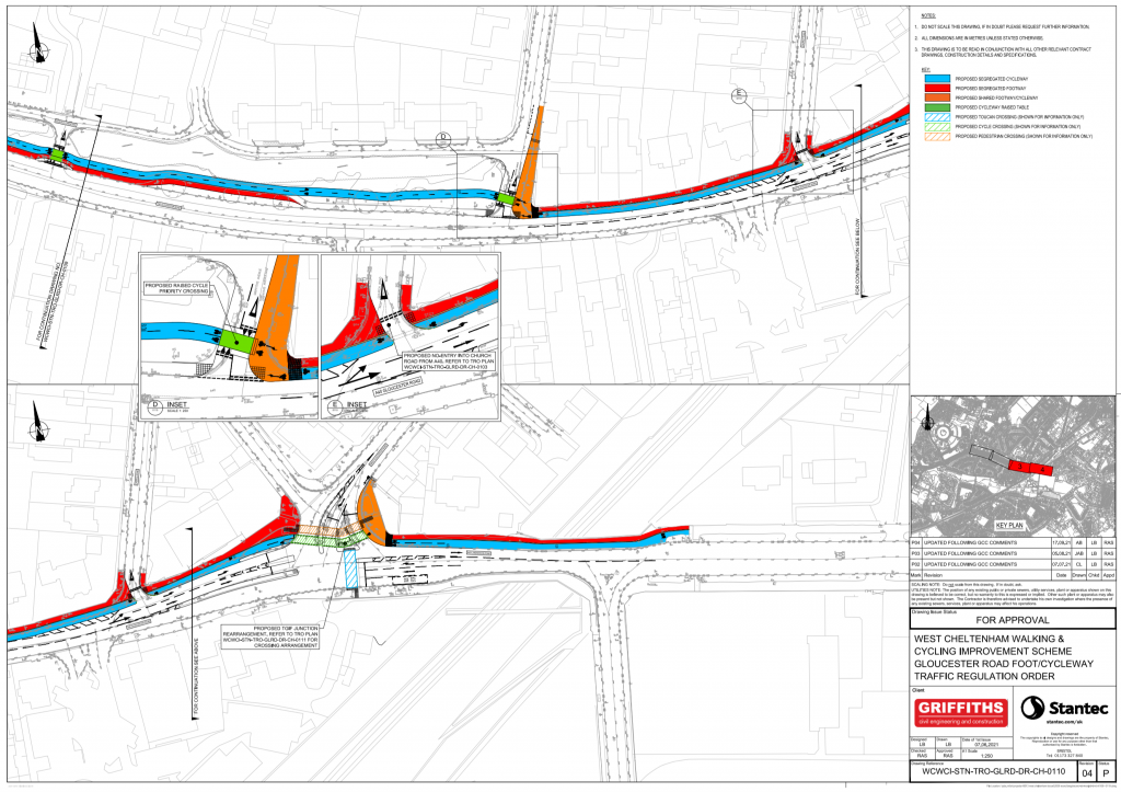
You’ve recommended a shared path!?
We’ve welcomed the significant junction realignment at Griffiths Avenue to address the blind corner, again noting the importance of highlighting the priority for cycle users across the raised table through colour and symbols.
Our second area of high concern on the plans was the narrow widths along the following section to Gloucester Road. The cycle path is already below recommended width at only 2 metres, with no buffer from traffic (a 0.5m buffer would be minimum for 40mph). Footway width is similarly compromised, particularly as vegetation is not regularly managed, and we anticipated that the drawn scheme would inevitably see pedestrians want to walk in the cycleway. The presence of the raised dividing kerb between cycleway and footway is also relevant here, as cycle users have no easy ability to deviate outside the 2 metres to pass, with cyclists inevitably ending up perilously close to a tall kerb drop into 40mph traffic.
We’ve considered the alternative arrangement of moving the footpath adjacent to the road. However, this creates an incredibly poor pedestrian experience so close to fast traffic, and again, we anticipated that pedestrians would choose to walk into the cycleway. We’re not prepared to support an arrangement that would expose pedestrians to the same risks we want cycle users to be protected from.
Our preferred solution here would be to either develop an alternative route (eg through filtering Libertus Road), or to lower speeds to 30mph and take more motor vehicle width away to give to cycle and pedestrian traffic, and build properly sized paths. However, this is out of scope for change based on decisions already made by the council.
We’ve therefore taken the unusual step of recommending a shared path here, as we believe it provides the only safe arrangement for cycle users to be able to pass safely, and for the majority of users to be able to stay away from the fast traffic (whilst recognising the compromises of shared spaces for all users of them). Whilst segregation would have been our desired solution, the maximum possible width achievable over a significant section is too dangerous, particularly with a kerb drop into 40mph heavy vehicle traffic. We hope this will be reviewed in future, and road width given to converting this section to segregated provision.
Church Road
We’ve welcomed the closure of the swept exit of the A40 onto Church Road, noting the substantial safety benefit this will bring. We’ve again highlighted here the importance of designing to ensure an exiting vehicle looks both ways, including the use of secondary signage on the approach.
Gloucester Road
We’ve welcomed the segregated crossing here, and stressed the importance of providing a single phase crossing wherever possible. By retaining shared space up to the crossing, the scheme also ensures cycle users have a route to exit up towards the station. On the eastern side, we highlighted the importance of a flush transition from the carriageway onto the shared space to access the crossing.
The section on Lansdown road to the east of the junction is receiving only minimal repairs. We’ve highlighted the need for the tree to be trimmed to a cyclist’s height, and that whilst repainting segregation here will be helpful, cycle’s need access to the width given the narrowing of the railway bridge and barrier.
Future Plans
Whilst outside of scope, the meeting also gave the opportunity to briefly discuss other connecting priorities that will emerge as this route develops;
- An improved route from the Gloucester Road junction to Shelburne Road to access the Honeybourne connection once built. (This will need to be from both the Shell garage side, and from the existing Toucan crossing after the railway bridge.
- Removing the barriers on the cut through to Campden Road and improving safety along the Campden/Miserden Road route, particularly at the Benhall Avenue crossing.
- Improving the route from Benhall Roundabout to the north entrance of GCHQ.
We believe it was a really constructive meeting, and showed the considerable benefit of connecting officers in control of schemes with our local expertise. We were able to explore challenges together, whilst understanding the constraints, and the opportunity to meet before work had commenced was particularly valuable for all parties.